Because you’re reading the phrase “climate change,” you can be certain bad news is imminent. In this case, the messenger is the National Ocean and Atmospheric Administration (NOAA) with its new “Climate Normals” report. And, indeed, temperatures in the US have been increasing steadily. Potentially making America a wetter nation as they do.
The NOAA recently dropped its report, which stands as the tenth in a series dating back to 1901. The administration has collected data ranging back to the early 20th century in the hopes of creating a “ruler” capable of predicting weather conditions in the near future. This report, like all the others, covers a timespan of 30 years.

NOAA
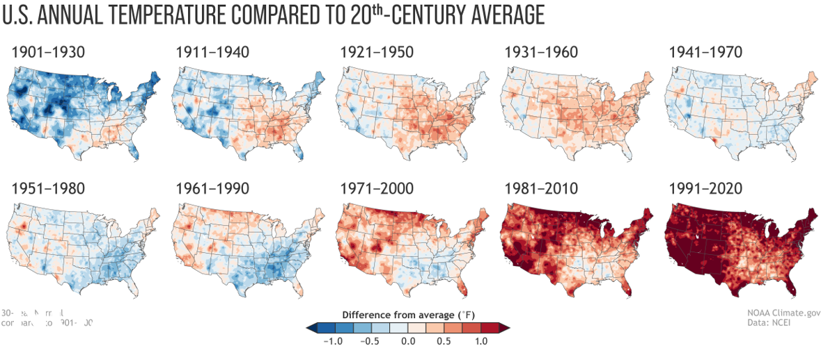
As for the highlights, the NOAA outlines two: a glaring increase in average temperature and signs of an overall increase in precipitation; i.e. rainfall. The NOAA shows each trend in the charts above and below, marking changes over time with varying colors. In the temperature chart, darkening blues mark cooler temperatures, while darkening reds mark warmer ones. In the precipitation chart, darkening greens and browns mark the trend; with the former color representing an increase in precipitation and the latter, a decrease.
The trend in the temperature chart is clear. This latest period (from 1991 to 2020) has seen the highest increase from the average temperature out of any other reporting period. Meaning this latest 30-year period has the highest average annual temperature ever. Spiking in many places around the country to more than 1 degree Fahrenheit. “The influence of long-term global warming [on the average annual temperature] is obvious,” the administration notes.

NOAA
As for the precipitation charts, signs of an overall change in average annual rainfall are more ambiguous. “[F]ew places exhibit a precipitation trend that is either steadily wetter or steadily drier than the 20th-century average,” the NOAA says. Adding that, instead, wetter and drier areas shift back and forth without a clear pattern.
However, the NOAA does speculate that “it’s probably not a coincidence” the last four precipitation maps are “nationally the four wettest-looking maps” in the collection. The administration also says that this “wetting” of the atmosphere is linked to overall climate change, as warming temperatures cause more evaporation. In terms of what that trend looks like on the ground, examples can be quite ghastly.
